Sunday, December 5, 2010

The Yreka Ditch ~ 1853


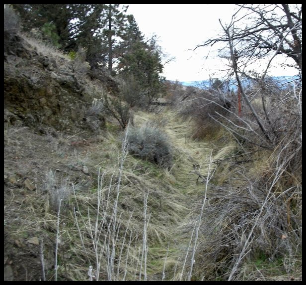
Views of "The Yreka Ditch" just west of the Weed Airport.


It was 1851 when the first gold was discovered on Yreka “Flats” and within a very short time the area was crawling with miners hungry to find the promise of gold! Placer mining was the technique for the area and worked well as long as water was available. By late fall, however, water became in short supply. According to Richard Silva in his extensive research and his publication, “The Big Ditch” (published by the Siskiyou County Historical Society and Museum in 2002) he states that water, or “liquid gold” was “so limited that some miners made more money selling it [water] than panning for gold”.

The need for water during the dry months became more evident and as early as 1853 the Yreka Ditch Company was formed with the purpose of creating some sort of flume from the Shasta River to the mines both north and south of Yreka. Eventually a decision was made to create a channel rather than use a flume the entire distance. In due course the ditch was created and dug entirely by hand with crude tools of the era. It was completed within two years an amazing feat considering its length. The ditch is approximately 95 miles long and begins on the Shasta River just northwest of present day Weed. Although only about 30 miles “as the crow flies” the ditch winds around the foothills of the Shasta Valley on the western slope and in some areas travels west considerable distance. The ditch ran the entire west side of the valley and ended at Canal Gulch in Hawkinsville.

View of the Yreka Ditch along the edge of the hills along the Gazelle - Callahan Road.

According to Silva it was March of 1856 when water was turned into the ditch at the Shasta River, but because of a variety of problems such as squirrel holes, seepage and unsettled soil and leakage in flumes that crossed small ravines it took the water five months to reach Yreka. Once up and running it delivered 21,000 gallons of water per minute and sold to the miners for their use in placer mining at 50 cents per “miner’s inch”.

Much of the “big ditch” can still be viewed today as one travels between Yreka and Weed area along the hillside to the west. Parts of the ditch are gone and the land no longer bears any resemblance to it ever being there, but sections of it are actually still in use today, other sections are visible but have filled in with soil due to erosion and appear quite shallow! Several names have been used in reference to this engineering marvel of its day, according to the information in Richard Silva’s book, among the more well known names were: The Edson-Foulke Company Ditch, The Big Ditch, and the China Ditch as well as the Yreka Ditch. Silva goes on to point out that Chinese laborers did not construct the ditch; it was completed by miners, farmers, and other individuals. Apparently, the Chinese were quite involved with continuing the maintenance of the ditch once it was completed.
A copy of this great read, The Big Ditch, by Richard Silva can be purchased at the Siskiyou County Museum Gift Shop and usually at the The Book Store on Miner Street in Yreka.

A view of a portion of the Yreka Ditch that is no longer in use


Photos and Text Copyright: Claudia East, 2010


Tuesday, October 19, 2010

Yreka, Capital City ~ State of Jefferson


In December of 1941 Yreka was named the new Capital of the State of Jefferson. It was an exciting and fast moving time when counties from southern Oregon and Northern California first said the word “succession” from their respective states and wanted to form a new 49th state!

This particular movement started with the “Curry County Incident” where a group of folks decided that Southern Oregon and Northern California were being ignored. Roads were bad, bridges were old, and our area was rich with timber and mineral resources that could easily be used for the war effort in Europe against Hitler. On November 17, 1941 a group from Curry County Oregon met with the Yreka Chamber of Commerce to discuss how they could develop our timber and resources for the war effort and our economic prosperity. Much discussion, planning, and late night activities prevailed by the movers and shakers of the time. Yreka’s 20-30 Club, comprised of young businessmen, were instrumental in keeping their plight in the news by feeding information via the state of the art teletypes and telegraphs in the area to major papers in San Francisco and beyond. Parades were held in various towns throughout the area and a favorite protest sign about the conditions of our roads was: “Our roads are not passable, they are hardly jackassable!”

Ten days after that meeting, on November 27, the Yreka 20-30 Club presented their Proclamation of Independence for the hopeful new state. Road blocks were set up along Highway 99 (the main artery of the time heading north and south) at intermittent times. Folks stopped cars and passed out the Proclamation of Independence and then let them on their way. One day a week it was suggested that merchants keep buckets by their cash registers and keep the sales tax from California sales to go to the State of Jefferson.

December 2, 1941 the news media descended upon Yreka and began to report the news of the budding new state and creating news reels to be shown in the theaters of the day. (Newsreels were the CNN and Fox News of 1941; no television, just radio, newspapers and the newsreels one would see at the movies.) The San Francisco Examiner even sent their star reporter, Stanton Delaplane to cover the events. As an interesting side note ~ later Mr. Delaplane received the Pulitzer Prize for his coverage on Yreka and The State of Jefferson in 1942.

On December 4, 1941 a large parade was held in Yreka. Folks from all the counties involved came and marched, there were bands from various areas, folks carrying signs and torches, cars and trucks full of enthusiasts and the streets were packed with observers. On the Siskiyou County Courthouse Square the inauguration of the new Governor of the State of Jefferson, Judge John Childs, from Del Norte County was sworn in and gave a stirring speech to the overflowing crowds. It was the culmination of a swift and productive movement. Folks were told the newsreels would be shown on December 8, 1941 and the new state citizens were eagerly awaiting the reaction of the rest of the United States!

The newsreels, however, were never shown; on December 7, 1941 Pearl Harbor was bombed by the Japanese and the United States suddenly was at war. On December 8, 1941 a statement was issued to the press by the State of Jefferson Territorial Committee that the current national emergency was of highest importance and all activity of the State of Jefferson would cease.

The State of Jefferson although not an actual separate state, has existed as a state of mind for many citizens within northern California and Southern Oregon for over 155 years. The first recorded news account of this area seeking independence (by this author) was in The New York Daily Times, January 1855.

Copyright, Claudia East

Saturday, June 26, 2010

Yreka a major stage destination!


Yreka, Miner Street View Circa 1905


Yreka was considered a major hub in the transportation world of Northern California for over 100 years. Yreka is half way between San Francisco and Portland and was also the major starting and ending point for most of the smaller towns and villages for a great many miles. The "stage" brought so many important things to the community. Mail being one of the most important. The miners would come to town to wait for the mail, and near the stage stop folks met and talked over all of the news of the day. In Yreka the main stage stop was along Miner Street right at or near the Franco-American Hotel. The post office was also located nearby.

The stage office (often called the express office) was a thriving business. There were big steel strapped boxes often filled with gold dust that were lifted up into the front boot under the drivers seat and secured by lock and chain to the floor. This was a security measure so if some enterprising thief wanted to hold up the stage for the gold they would have to wrangle this off themselves. On board the stage was a Express messenger that carried a sawed-off shotgun loaded with buck shot. The cost of running the stage company was no little amount, estimated to be an annual expense of $40,000 in addition to paying tolls over many of the roads they traveled. This could amount to another $12,000 a year for the rights to use the roads.

The California and Oregon system is reported to have used about 430 miles of roadway and its branches alone served from Redding to Roseburg, via Yreka, Ashland and Jacksonville; Redding to Yreka, via Shasta, Tower House, Trinity Center, Callahans, Etna and Fort Jones and others. This operation alone utilized nearly 400 horses with 20 drivers in the summer and 26 in the winter. There were 50 stablemen, 6 mechanics and horse-shoers in addition to the clerks in the offices. They ran 16 stages in summer and 21 in winter besides 2 large sleighs over Scott Mountain in snow time. Horses had to be changed every 12 miles and a new driver took the reins each 10 hours. And, this was only one of many stage lines that came through Yreka.

Friday, June 4, 2010

Methodist - Episcopal Church


Left: Three churches around Courthouse Square in Yreka, The Union Church, St. Mark's Episcopal Church, and the Catholic Church, circa 1889.


Right: The Methodist-Episcopal Church corner of Lane and Oregon Streets, 1898.


As early as 1852, only one year following the discovery of gold in Yreka, a Methodist Minister was holding services in Yreka. The first site of a Methodist Episcopal Church was on the southwest corner of Miner and Oregon Streets where the Ley Fire Station now stands. It was a humble log cabin. This little log church served the congregation until about 1854.

In early Yreka it was found that a more proper and larger church needed to be built. The various denominations, including Catholic, Methodist, and Presbyterian joined together to build a church at the corner of South Oregon and Lane Streets, this new church was called the "Union Church" and was dedicated in March of 1855. Later the Union Church was sold to the Methodist Conference for financial reasons. This first church building, made of whip-sawed timber and hand planed finishing lumber served Yreka until early in 1898. This original church, according to the Yreka Journal, was carefully taken down for the construction of a new church ~ the image viewed above. The corner stone for this new Methodist Episcopal Church was laid on June 11, 1898. Some of the contents laid within the corner stone were: A Holy Bible, a copy of the Yreka Journal, June 11, 1898, the names of the minister, trustees and others, and a dime found in the old church dated 1862. This new church building was completed and the formal dedication was in March of 1900.

In 1964 the current Methodist-Episcopal Church in Yreka held groundbreaking ceremony at the corner of Fairchild and Cedar Streets where the current services are held. The building in the image above was torn down in 1970. The Girdner Funeral Home currently occupies the site where a Methodist-Episcopal Church sat for 115 years.

For those of you that have our book, Yreka, Images of America Series by Arcadia Publishing will find another copy of this image as well as one on the Methodist parsonage on page 72.

Copyright: Claudia A. East
*Information gleaned from a 1980 Publication titled, Methodism in Yreka 1852 - 1980 The Yreka United Methodist Church, Authored, and compiled by Verna Bray Tyrer and Harland McDonald. Printed by Nolan Litho, Yreka, CA

Monday, April 19, 2010

Masonic Hall Building


The Yreka Masonic Hall Building
304 West Miner Street, Yreka, CA


Photo Copyright: Claudia East

Situated at the center of the historic district on Miner Street in Yreka is the Masonic Hall Building. This building was built in 1926 and was funded by Masonic Orders who sold shares at $50 each to finance the project. The lower level was originally drafted to house three different businesses and the rental of those spaces helped to fund the Masonic Order. The second story, or top floor was reserved for Lodge activities. A plaque on the front of the building explains that early on the Denny Bar Company (first chain store in California) operated here along with the Electric Company owned by Ernest Millbourn and for awhile the Klamath National Forest offices. In the 1933 City Directory Churchill-McDonald Builders and Hardware was listed at 300-302 West Miner, their phone number was #9. In the 1980s Cooley & Pollard Hardware purchased the downstairs portion of the building from the Masonic order and has operated at this location since the 1930s.

Prior to this building being constructed as early as 1880 there was a brick building at this location that housed Engine & House No. 1 the Yreka Fire Department. Adjacent to the fire house was another building that was home to offices. The area that the current building sits upon was once known as the Wetzel lot and the Whiting Building in earlier times.

For those of you that have a copy of our book, Yreka, from Arcadia Publishing Image of America Series you will find photos of the building taken in the late 1920s on page 38. You will also find photos of the building that was located at this spot prior to this "new" Masonic Lodge being built in 1926 on page 116. Additional photos of the interior of the earlier lodge can also be found on pages 112 and 113.

Information for this post was obtained from Archie Noonan's 1976 manuscript Yreka's West Miner Street Buildings, Blocks 200 - 300, 1851 - 1900; from information published on the historic marker sign at the building; references to old City Directories as well as from personal knowledge.

Copyright: Claudia A. East, 2010