


Views of "The Yreka Ditch" just west of the Weed Airport.
It was 1851 when the first gold was discovered on Yreka “Flats” and within a very short time the area was crawling with miners hungry to find the promise of gold! Placer mining was the technique for the area and worked well as long as water was available. By late fall, however, water became in short supply. According to Richard Silva in his extensive research and his publication, “The Big Ditch” (published by the Siskiyou County Historical Society and Museum in 2002) he states that water, or “liquid gold” was “so limited that some miners made more money selling it [water] than panning for gold”.
The need for water during the dry months became more evident and as early as 1853 the Yreka Ditch Company was formed with the purpose of creating some sort of flume from the Shasta River to the mines both north and south of Yreka. Eventually a decision was made to create a channel rather than use a flume the entire distance. In due course the ditch was created and dug entirely by hand with crude tools of the era. It was completed within two years an amazing feat considering its length. The ditch is approximately 95 miles long and begins on the Shasta River just northwest of present day Weed. Although only about 30 miles “as the crow flies” the ditch winds around the foothills of the Shasta Valley on the western slope and in some areas travels west considerable distance. The ditch ran the entire west side of the valley and ended at Canal Gulch in Hawkinsville.

View of the Yreka Ditch along the edge of the hills along the Gazelle - Callahan Road.
According to Silva it was March of 1856 when water was turned into the ditch at the Shasta River, but because of a variety of problems such as squirrel holes, seepage and unsettled soil and leakage in flumes that crossed small ravines it took the water five months to reach Yreka. Once up and running it delivered 21,000 gallons of water per minute and sold to the miners for their use in placer mining at 50 cents per “miner’s inch”.
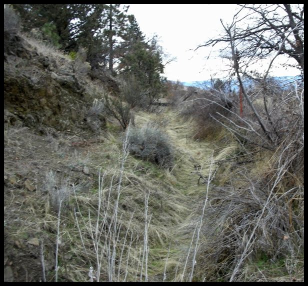
Much of the “big ditch” can still be viewed today as one travels between Yreka and Weed area along the hillside to the west. Parts of the ditch are gone and the land no longer bears any resemblance to it ever being there, but sections of it are actually still in use today, other sections are visible but have filled in with soil due to erosion and appear quite shallow! Several names have been used in reference to this engineering marvel of its day, according to the information in Richard Silva’s book, among the more well known names were: The Edson-Foulke Company Ditch, The Big Ditch, and the China Ditch as well as the Yreka Ditch. Silva goes on to point out that Chinese laborers did not construct the ditch; it was completed by miners, farmers, and other individuals. Apparently, the Chinese were quite involved with continuing the maintenance of the ditch once it was completed.
A copy of this great read, The Big Ditch, by Richard Silva can be purchased at the Siskiyou County Museum Gift Shop and usually at the The Book Store on Miner Street in Yreka.
A view of a portion of the Yreka Ditch that is no longer in use
Photos and Text Copyright: Claudia East, 2010